Control Panel
The control panel allows you to view and edit the installation settings of MapMint . Forms are automatically filled with the content of the main.cfg settings file .
Warning
It is not advisable to change the configuration settings without knowing the consequences
The control panel is divided into 4 sections, listed below. Clicking on the icon causes the display of the tab.
As presented in the previous screen, once you have edited the configuration settings, you to use the “Save” button at the top right of the panel to save your changes.
Icon |
Action |
 |
General configuration |
 |
General configuration |
 |
Provider Configuration |
 |
Configuring the database |
General configuration
The general configuration form together the environment variables and installation parameters of the instance MapMint.
Parameter |
Definition |
| Encoding | Define the encoding of the default installation (utf-8) |
| Mmadress | Set access to the default instance URL (/ mm /) |
Data path |
Set path to the / data storage dedicated to data |
| Jscache | Defines if the javascript files are compressed or not (prod | dev) |
Tmp path |
Sets the path to the temporary file storage directory (/ tmp /) |
Cache dir |
Set path to the cache storage directory (/ cache /) |
| 3D | Sets the 3D Activation (false | true) |
Root url |
Set the URL to access the public interface by default (/ public /) |
publication Url |
Set publishing URL where files are stored (/ public_map /) |
Db link |
Set path to the database instance users MapMint |
| Mmpath | Set the full URL of the default installation directory (/ mm /) |
| Version | Sets version number MapMint |
| Rpy2 | Sets the activation of the bookstore R (true | false) |
Db user |
Sets the name of the corresponding section in the parameters of the database |
Application adress |
Sets the instance root address MapMint |
| Lang | Defines the languages supported by the instance |
| Sesspath | Set path to the session temporary files storage directory (/ tmp /) |
Publication path |
Set path to the instance publishing directory MapMint |
| Csscache | Defines whether the CSS files are compressed or not (prod | dev) |
| Msogcversion | Sets the version of the WMS and WFS services MapServer |
Server address |
Set the URL to access the executable ZOO-Project (WPS kernel) |
Db username |
Sets the name of the storage space corresponding to the user database |
Address templates |
Set the URL to access the files models generated by the application (for windows and tooltips) |
| Language | Sets the language of the proceedings |
| Mapserveradress | Set the URL to access the executable MapServer |
| Tmpurl | Set the access URL to the temporary directory (corresponding to the path tmp Path) |
templates Path |
Defines the full path to the directory mapmint-ui / templates |
General configuration
configuration forms of ID and provider of services used to characterize the organization that publishes the data and the person responsible for the server and / or MapMint application.
Parameter |
Definition |
Name position |
Sets the position of the reference switch |
Individual Name |
Sets the name of the individual reference contact |
Provide rname |
Defines service provider name |
Administrative Area Address |
Sets the administrative sector of the service provider |
Country address |
Sets the service provider in the country |
Phone Voice |
Sets the reference contact telephone number |
Address Postal Code |
Sets the postal code of the service provider |
| Role | Sets the service provider role |
Providersite |
Sets the address of the service provider’s website |
Phone Facsimile |
Sets the fax number of the reference contract |
Address Electronic Mail Address |
Sets the email address of the benchmark contract |
address City |
Defines the city the service provider |
Delivery Point Address |
Sets the service provider’s address |
Note
These parameters are used to define metadata “open geospatial web services” (OWS) defined by the Open Geospatial Consortium (OGC).
Note
The reference contact usually is the name of the person responsible for the server
Service Provider Configuration
Parameter |
Definition |
| Keywords | Sets keywords assigned to web services, separated by commas |
| Title | Sets the title of the map server |
| Abstract | Sets the map server with a short description |
Access Constraints |
Defines if the map server requires authentication |
| Fees | Defines the terms of use and / or the copyright server |
Note
These parameters are used to define metadata “open geospatial web services” (OWS) defined by the Open Geospatial Consortium (OGC).
Note
The service provider usually is the name of the organization that publishes data
Warning
The title and description of the server are also used in the home page of the public interface
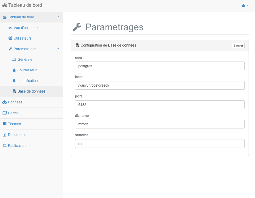
Configuring the database
The Database Configuration page is only available when using a PostgreSQL type of database to store user information. In case you would use the SQLite database, this section should not appear.
Parameter |
Definition |
| user | Sets the user name to use to connect to the database server |
| host | Sets the name of the machine or Unix domain socket used to connect to the database server |
| port | Sets the port to use to connect to the database server |
| dbname | Sets the name of the database to use |
| schema | Sets the schema used for storing system tables |
| password | Sets the password to use to connect to the database server |